The novel technique of seismic oceanography allows us to relate water column seismic reflections to oceanic mesoscale to fine scale structures. To date, it has been used to capture many oceanic features successfully. However, no seismic study has reported the detailed structures and properties of the widespread surface eddies, which have been extensively studied using the conventional methods whose resolution are coarse. In this study, finescale structures of a surface anticyclonic eddy (Figure 1) have been unveiled by reprocessing two seismic transects by Dr. TANG Qunshu and his workgroup. The legacy seismic data were acquired in the northern Gulf of Alaska using an 8 km hydrophone streamer and 6600 cu in linear airgun array in September 2008.
The imaged warm eddy was atypical bowl-like mesoscale structure with around 55 km width and 700 m depth. In the sub-mesoscale context, it has two fringes around the eddy base and a spiral arm at the NE edge. The in situ sea surface temperature and salinity data from a shipboard thermosalinograph help to confirm our interpretations of a spiral arm shed from the warm eddy and the entrained cold water from elsewhere. Nearby the eddy and offshore the shelf-break, there is a strong front alfeature, probably the Alaska Current. The measured eddy’s equivalent diameter is~65 km from the along-track altimeter and the seismic constraints. It was comparable with results from the representative conventional algorithms of eddy detection. Further, from the dipping seismic reflections, geostrophic velocities of the eddy (Figure 2) were estimated under the assumptions of approximate isopycnals and geostrophic balance.
By tracking the sea level anomalies, the workgroup of Dr. TANG found that the eddy likely formed offshore Yakutat shelf and transported along the offshore shelf-break. Measured water properties including sea surface temperature, salinity, and chlorophyll revealed that eddy translation transports coastal water to the pelagic regions. Finally, they searched the historical hydrographic profiles sampling an earlier eddy to synthesize the seismograms, showing that the thin striae around the eddy base might be a common feature in the Gulf of Alaska.
This study was supported financially by the National Natural Science Foundation of China (grants 41176026 and 41376023) and the U.S. National Science Foundation (grants EAR-0408584 and EAR-1009986). This is University of Texas Institute for Geophysics contribution #2708.
This work entitled “Seismic observations from a Yakutat eddy in the northern Gulf of Alaska” has been published in Journal of Geophysics Research–Oceans.
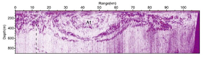
Figure 1.Seismic image of line STEEP13. A1 marks the bowl-like structure (Yakutat warm eddy).This figure was selected as the Featured Image Carousel of JGR-Oceans.(Image by SCSIO)
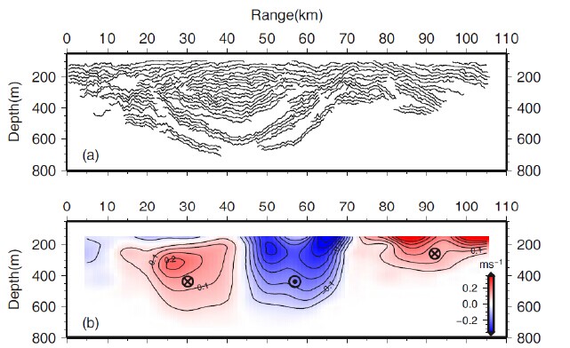
Figure 2.(a) Tracked horizons from seismic transect Line1. (b) Geostrophic velocity field perpendicular to STEEP13. (Image by SCSIO)