A legacy seismic transect acquired on 30 and 31 May 2009 in the southern South China Sea (SCS) was reprocessed to reveal the thermohaline structure of the water column by Dr. Tang recently. In the study region, a mesoscale subsurface lens with extraordinary features was detected at 113.5° E, 11.5°N. It is centered at 450 m depth, occupies both the subsurface and intermediate water from 250 to 600 m, and has an intersection diameter of around 60 km.
Such a feature is very similar to the Meddies in the subsurface layer of the Atlantic Ocean. However, no previous report has observed or suggested that a subsurface eddy could exist or be formed in the southern SCS. Professor D. X. Wang considered that such a mesoscale structure could be simulated by the high resolution ocean models. Therefore, they combined the model data with the seismic result to find the correspondence for the first time. The simulated results from Hybrid Coordinate Ocean Model (HYCOM) show a distinct subsurface current, and math quite well with the seismic observation spatially. It was an eddy-induced subsurface current running southwestward along the deep basin edge. Further analysis suggested that the imaged lens is a snapshot of the subsurface current core rather than a subsurface eddy.
This work has been published in the journal of Ocean Science (Tang, Q. S., D. X. Wang, J. B. Li, P. Yan, and J. Li (2013), Image of a subsurface current core in the southern South China Sea, Ocean Sci., 9, 631-638). It was supported financially by the NSFC (Grants 41176026, 91228202, and 41006027) and the 973 Program (Grants 2007CB411700 and 2007CB411706).

1. Detail of the subsurface lens.
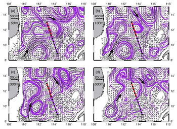
2. HYCOM simulated velocities at different depths in the southern SCS on 30 May 2009. The purple lines are the streamlines derived from the velocities. Black arrows show the current directions at some key spots. The seismic transect with labeled distances is also superimposed.
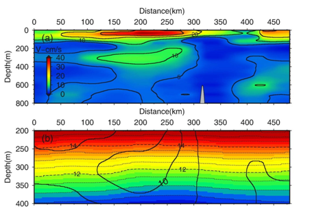
3. Vertical sections of the HYCOM simulated current speeds (a) and temperature (b) along the seismic transect. Speeds contours in (a) are also superimposed in (b).