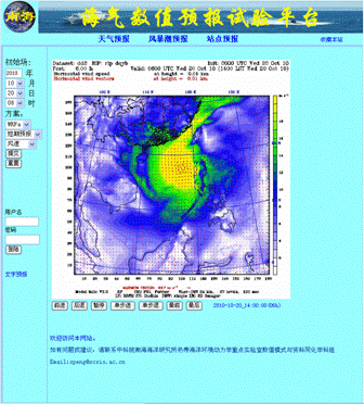
An Experimental Platform of Air-sea Numerical Forecasts has been set up in South China Sea Institute of Oceanology (SCSIO)
Recently, the research group led by Professor Shiqiu Peng has made promising achievements on the South China Sea regional numerical simulation and data assimilation. An Experimental Platform of Air-sea Numerical Forecasts (EPANF) has been set up preliminary. The platform has successfully forecasted the strength, track, landfalling of the super hurricane ‘Fanapi’ and the corresponding coastal storm surge, the rainfall disaster (once over 200 years) in Guangdong on September 21 and continuous 8-day heavy rainfall (once over 50 years) in Hainan during October 1-8. In particular, the platform has exactly predicted the track turning point at about 08 am of October 20 two days ahead for the super typhoon “Megi” which is the strongest one generated in the West Pacific during Autumn over the last several decades.
The forecasting system includes a two-domain-nested atmospheric model and a high-resolution ocean circulation model. A 72-hour (short term) forecast and a 15-day (medium term) prediction for the atmospheric states over the South China Sea and its surrounding areas are carried out, respectively. The ocean circulation model employs a high-resolution three-dimensional storm surge model, which uses the wind and pressure fields provided by the inner domain of the atmospheric model as external forcing and makes a 48-hour storm surge forecast. The experimental platform routinely/automatically downloads the real-time data (mainly the United States NOAA's GFS data) required for generating the initial and boundary conditions for the models, and performs the forecasting every 6 hours, i.e., four time one day (at 02, 08, 14, 20 o’clock of each day, respectively).
The establishment of the platform provides important diagnostic analysis tools for the study of the mechanisms of South China Sea circulation/vortex, ocean mixing and air-sea interaction. It may also provide necessarily technical support for the successful implementation of the "973" national scientific and technological project, "The air-sea interaction and the evolution of ocean circulation and vortex in South China Sea" led by SCSIO, and lay foundation for the development of fully coupled high-resolution ocean-atmosphere-wave coupling model and real-time data assimilation system in the coming future. Meanwhile, through the application of the updated research achievements of the air-sea interaction, meso-scale vortices and inner mixing by the SCSIO oceanographers, it can also become a platform for examining the theoretic results as well as an exit of “from results to products”.
Appendix: the link and operating instructions to the experimental platform:
After entering the above linked page, click the button "weather forecasting" or "storm surge forecasting" to view the weather states (Including wind speed, air temperature, precipitation, etc., by selecting the left button) and the storm surge or current (By selecting the left button) over the South China Sea regions . You can also choose "short-term forecasts" (72 hours) and "medium-term forecasts" (15 days) by selecting the optional buttons on the left. And once you have selected the item you want to view, please click the button "Submit" or "reset" in the left.
